
The Temple Mount Location in Question

Amazon Prime offers a movie (also on DVD) called Jerusalem and the Lost Temple of the Jews, which discusses where the first two temples were built and where a third might be built before the Messiah's return.
You may have heard for years that the currently named "Temple Mount" may not be the correct location. This movie uses as its main sources: The Bible, The Works of Josephus the Historian, and the Book of Maccabees.
According to this documentary, It is quite possible that the Temple Mount is actually 1/3 of a mile south of the currently-named Temple Mount, located in the City of David. Here is a summary of the evidence:
1. The Bible says in Matthew 24:1-2 that as Jesus went out from the temple with His disciples. He pointed to the temple buildings and said to them…”Assuredly, I say to you, not one stone shall be left here upon another, that shall not be thrown down.” Jesus was prophesying about the destruction of the temple in 70 AD. Jerusalem and her temple were, in fact, destroyed just as Jesus predicted. However, when you look today at the “temple mount,” you will see its Western Walls still standing. These walls are what supported the “temple mount,” and according to Jesus, not one stone should be stacked upon another. This fact raises a question, is this the right location?
Herod built two fortresses – one was the Antonia Fortress. He also built the Jewish Temple. When Titus destroyed Jerusalem, he destroyed the temple, down to the foundations. Many stones left in the walls are still standing - 10,000 of them. Either Jesus was not precise (which we know can’t be right) or we are missing something. Archaeologists say that these stones were not destroyed because we are looking at Antonia's Fortress, which is outside the City of Jerusalem. The Antonia Fortress is located just north of David's City and was built to accommodate a legion of Roman soldiers. The currently-named Temple Mount is the site of Herod’s Antonia Fortress.
To learn more about this topic, register for our upcoming conference, March 4th from 3 - 7:15 pm with guest speaker David Sielaff speaking on this topic. For more information, click here.

2. Josephus was a Jewish historian who wrote in the late 1st century. He was an eyewitness for the period of time when Jerusalem was destroyed. He was from the tribe of Levi – a Priestly family. He could have served in the temple. The Romans gave him access to the high court records of Herod and to the temple books. Josephus wrote a detailed account of the size and proportions of the temple and the Antonia’s Fortress. Antonia's Fortress was used to house 6,000 troops of the 10th Legion. This Fortress was a 35-acre site and much larger than the temple. However, if you visit the temple mount today, the so-called Antonia’s Fortress is much, much smaller than the temple could have been. In addition, the Fortress wall protrudes from the wall, whereas Josephus states it is flush with the wall. The southeast tower was 1.3 larger than the other 3 towers so they could view the temple.
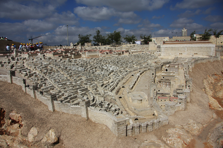
Holyland model of jerusalem
The Holyland Model of Jerusalem is a 1:50 scale-model of the City of Jerusalem of the late 2nd Temple period, created by Israeli historial and geographer Michael Avi-Yonah, based on the writings of Josephus. Some use this model as historically accurate, however, it does not exactly match the dimensions Josephus wrote about.
Josephus claims that Antonia's Fortress is flush with the wall. The Fortress sat on a 35-acre parcel of land, not just a little fortress attached to the wall.

A sample of a colonnade
3. Another issue with using the Holyland Model for accuracy are the two 600-ft. colonnades mentioned by Josephus in the section called Wars of the Jews. These two colannades (called arms) denote a long sequence of columns. They joined the Temple Mount buildings with Antonia's Fortress, connecting on the Northwest corner of the temple. They were 50 cubits high and built on a rock that was 75 ft. in height. These do not appear in the Holyland Model and are significant as a major battle took place on these colonnades. Titus watched this battle take place. There is no such rock at the Temple Mount. According to Josephus, Jerusalem was built upon two hills opposite one another. On one of these hills is where the upper city called the Citadel by King David s located. The Valley of the Cheesemongers (later called the Tyropoeon Valley) was in the middle of the two hills.
4. An archaeological dig unearthed of a 7th-century market called the cardo which was built by Justinian. Stairs lead down 20 feet, but the city was buried deeper than that during the first century. The Old City wasn’t in this location, but Southeast of there. It was called the City of David.
5. More evidence that the Temple Mount is not where it is said to be today can be found in writings left from the few survivors of Masada who wrote about the destruction of Jerusalem. They state that the temple and the city were completely destroyed and the only thing remaining of significance was Antonia’s Fortress. The Fortress was not considered part of Jerusalem because it was outside of the city. It is now believed that the currently-named Western Wall (i.e. Wailing Wall) is actually the fortification that supported Antonia's Fortress and not the Temple.

Hezekiah's tunnel
6. The discovery of Hezekiah’s tunnel that led to the waterway was an important archaeological discovery. It was built in 700 BC by Hezekiah to rechannel the water from the Gihon Spring from the outside to inside in order to protect their water source from invaders. The discovery of Hezekiah's tunnel proves that the City of David was just above this tunnel. It proves that the City of David is on the southeast ridge and not the southwest hill. The "City of David" was synonymous with "Mount Zion" and the Jewish Temple. Solomon, David's son, built the Temple over the Gihon Spring. There was no other source of water for Jerusalem within a five-mile radius.
7. In the time of Simon the Hasmonean, the current temple mount was not the highest mountain. Mt. Zion is where the Temple was located. The Temple was descrated by Greeks during the time of the Maccabees. Simon the Hasmonean decided to remove Mt. Zion. He leveled the land and threw it into the Tyropeon and Kidron Valleys. He filled up the valley with the earth and wanted to join the upper city with the Temple. The name Mt. Zion was transferred to the western hill and the city expanded to the west. This explains why this mountain cannot be seen today. What you see now is not what Josephus was talking about. It is difficult to look at Jerusalem today and picture what the geography used to be. We must rely on historical resources rather than on what we see.
Today tunnels lead to the foundation blocks of the "so-called Temple Mount." There are massive rocks in these tunnels. The Antonia Fortress is said to have been built on a plateau that was higher than the City of David. There are no other foundation blocks like this that have been found. Josephus calls this the third hill. The apex of this rock is where the Dome of the Rock is located. This is the Antonia Fortress.
The City of David is built on land in the shape of a crescent (according to The Works of Josephus). Satellite photos show the crescent ridge. It stretched from the Kidron to the Tyropoean Valleys and was built over the Gihon spring. The Temple Mount extended from one valley to the other and could not be extended further. The City of David is exactly 600 feet across. However, the currently-called Temple Mount is 900 feet across. This is just one more piece of evidence that this land has been misnamed.
If the above findings are true, then the currently-named location of the Temple Mount is false and has clouded truth, keeping the Jewish people from locating the proper site for their Temple. It seems that the problem has been that "tradition trumps eyewitness and historical records," according to the DVD. The Book of Maccabees also contributes details to the geography during the Second Temple period.
The DVD is based on the findings of Dr. Ernest Martin, who provides the following sketch of the Temple and the Antonia Fortress. Dr. Martin's book is called The Temples Israel Forgot.

Today, there is excavating going on in the City of David. Some of the findings are evidence that this is actually where the Temple was located. Once the Jewish people determine where their Temple belongs, they can rebuild it. The glory of Jerusalem will return!
To learn more about this topic, register for our upcoming conference, March 4th from 3 - 7:15 pm with guest speaker David Sielaff speaking on this topic. For more information, click here.